
Limitations
As my project is based nearly entirely on manuscript sources, this presents itself with a variety of limitations. These limitations not only hinder the time taken in completing work but also the overall feasibility of a positive outcome to the project resulting in a degree of incompleteness in regards to both mapping and plat drawing.
Reading the Manuscripts
Although it seems a fairly absurd notion, there is a large degree
of difficulty in being able to physically read the manuscripts.
This is due to a variety of factors including the more ornate
handwriting used in the 19th century when these manuscripts
were copied out, the lack of fomalised spelling leading to the
same word being spelled in a multitude of ways such as 'four',
'foure', 'fore' and 'fower', and the unfortunate nature of blurring
and the formation of shadows that occur when original
manuscripts are photocopied. These factors combine to leave
uncertainty in research in regards to firstly what the original
writer intended a word to say in the first place and can prevent
connections being made between individuals who may be
mentioned more than once within a patent book but under a
variety of spellings. This in turn leaves ambiguity when
transcribing manuscripts and transferring the information from
them onto a map.
Volume and Inconsistencies
There is a huge time constraint in using manuscripts as primary
sources; not only due to the difficulty of the language and visual
aspects but also due to the sheer volume of manuscripts available
versus how many are actual useful to one individual study. In the
three volumes of patents I focussed on there were over 1000 pages
each with multiple entries on. However, before even reaching the
patent books, a variety of databases had to be consulted in order
to identify the right volumes, the right people, the right place and
the right time period. As well as this there are a large number of
inconsistencies in the language used in awarding a plot of land.
As you can see from my database of land awarded to Port Royal
residents, land is primarily awarded North, South, East and West
a number of feet each way. However, due to inconsistencies in
language it is not always clear the direction of the land that is
awarded. For example, when using the phrase 'bounding northward
of the land of' as opposed to 'bounding north to the high street'
it would appear that one plot would be above the said land and one
below. However, throughout the entries it is clear this is not
necessarily what was meant due to the wording of further awards
and instead it could be considered that both pieces of land are above
or below. It also doesn't give exact locations in regards to a physical
position but instead just the circumference of the property and if
it borders someone elses land, making it almost impossible to piece
together accurately.
Unclear Geographical Locations
Across the entirety of West Indies, it is common to see similar
names repeating frequently. These are often religious names
such as St Thomas, St Andrews or St Mary's parish, surnames
used to claim land or else repetitions of land names from England
or names linking to the local surroundings. There are indeed
multiple Port Royals across the world causing a variety of difficulties
in the use of secondary sources for this study. However, in the
patent books there is little to no differentiation between identical
place names resulting in the research and transcription of a
variety of individaul awards that are not actually in Port Royal.
For example, a number of patents refer to individuals being
awarded land in St Thomas Parish, near Turtle Crawls. As you
can see from the annotated map of Port Royal in 1692, Turtle
Crawls is the name of part of the land and harbour to the East
of Port Royal. However, the land being awarded to these
individuals often came to between 300 and 500 acres; as Port
Royal only contained around 58 acres it is clear these plots of
land are elsewhere on the island. Unfortunately it is impossible
to identify plots such as these without reading the relevant
manuscript first which is naturally very time consuming.
The Deceased
There are two key problems with using manuscripts when talking
about land belonging to the deceased. The first is that it is unclear
if another person is gaining some land that previously belonged to
the deceased and the second is that land previously belonging to
the deceased is often divided and awarded to others without
indication that the previous owner is deceased, leading to a layering
affect on the land ownership map. When a person is awarded land
next to land previously owned by the deceased, the common phrasing
is 'eastwards on the lands now of late of Richard Brock fifty foot'. The
use of the word 'on' suggests that the person may be taking part of
the original parcel of land awarded to the deceased, however, the
word 'on' is also frequently used when awarding land bounding to a
specific street or to the sea. Therefore it is impossible to know whether
or not the deceased person's land is being split. When it is split and
given to different people it is often not clear, resulting in the layering
effect and the appearance of multiple ownership when trying to piece
together the land ownership map. Unfortunately due to the differing
conditions and propensity for disease, many people died young in the
Caribbean and therefore patent entries awarding land to one individual
can quickly be followed by the awarding of land to someone else
bordering the now 'late' individual's land.
Copies
The final limitation in using these manuscripts in particular as a source
to create historically accurate maps is that the original manuscripts
were copied in the 19th century, volume 1 in 1892 and volume 4 in 1888,
and were then destroyed. This means not only do we not have access
to the original manuscripts but we have to rely on the copies which
are littered with inaccuracies ranging from lines where the copier couldn't
identify the original word, blended words where the original copier
was unsure of a word and made a guess and inaccuracies in numbers
with the suggestion that someone who was being awarded 60 square
feet of land could have a side bordeing northward hundreds of feet long.
The only option in this case is to transcribe the copy as accurately as
possible and make an educated guess when it comes to incorrect numbers,
completing at least three sides of a plot if the fourth is not possible.
It's not all bad!
Despite the number of limitations faced in using manuscript sources, there
are a number of benefits as well. As opposed to using printed primary
sources, manuscript sources can be seen in full and entirely in context,
as opposed to having individual parts removed and printed as part of a
political agenda. Manuscript sources also have the benefit of containing
what at first appears miscellaneous information such as status or career
when looking for the statistics of land awarded in order to create a land
ownership map but instead allow you to build a fuller picture and identity
of the person behind the land ownership which stops them being simply
a name on a page and instead allows them a historical afterlife. Despite
the many limitations I have faced in using manuscript sources during the
process of this project, the additional infomation they contain and their
more untouched, less politically influenced nature give added value
and weight to the data they yield.
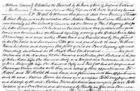
Land awarded to Arthur Towne, page 19, National Archives of Jamaica, Spanish Town, (hereafter NAJm) Patents Book 1B. A fairly neat example of the handwriting used throughout the patents
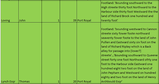
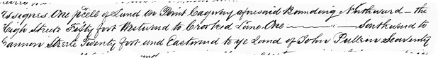
Examples of unclear directional data. Data in database in sourced from NAJm Patents Book 1B in the Jamaica Archives

Examples of unclear geographical locations. Data in database in sourced from NAJm Patents Book 4 and 6

Examples of confusion regarding land belonging to the deceased, in this case (Samuel Barry). Data in database in sourced from NAJm Patents Book 1B
Examples of 19th century copier being unsure of the exact transcription of the original document. Data in database in sourced from NAJm Patents Book 1B page 39